9,79€
DeliveryTue, 17 Sep - Thu, 19 Sep
+14,00 €shipping cost - sent from Greece
Selected Store
Stock 1 piece
Skroutz Buyers Protection
Set the delivery location to see products according to your choice.


 AustriaEnglish
 BelgiumEnglish
 BulgariaБългарски
 CroatiaEnglish
 CyprusΕλληνικά
 CzechiaEnglish
 EstoniaEnglish
 FinlandEnglish
 FranceEnglish
 GermanyDeutsch
 GreeceΕλληνικά
 HungaryEnglish
 IrelandEnglish
 ItalyEnglish
 LatviaEnglish
 LithuaniaEnglish
 LuxembourgEnglish
 MaltaEnglish
 NetherlandsEnglish
 PolandEnglish
 PortugalEnglish
 RomaniaRomână
 SlovakiaEnglish
 SloveniaEnglish
 SpainEnglish
 SwedenEnglish
© 20[0-9]{2} Skroutz SA All Rights and Lefts reserved. FAQ | Terms of use | Privacy Policy | Cookie Policy


Selected Store
Stock 1 piece
Skroutz Buyers Protection


Teaching Aid Books

Teaching Aid Books


Teaching Aid Books


Teaching Aid Books

Prices are calculated for:Malta, Other Payment Options
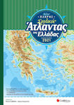
This geographical atlas contains over 150 maps from the collection of school atlases by the German publisher Klett-Perthes. The extremely detailed cartographic representation, the variety of thematic maps (political, geophysical, land use, economic, meteorological, etc.), the special large-scale maps depicting a well-known area or a particular aspect of a place (e.g., the center of London, the tourist areas of Switzerland, the areas where Native Americans live today in the USA) allow the user of the atlas to immediately gain a general overview of the world or to focus on a specific geographical unit.
The atlas is suitable for middle school students but will also meet the needs of adult readers interested in geography and the modern world.
It includes:
- World maps
- General thematic maps for each continent
- Detailed maps by region (for Europe at a scale of 1:5,000,000, for other continents at a scale of 1:15,000,000)
- Dozens of maps focusing on topics of special interest (urban planning, geological, economic, historical, meteorological, environmental, transportation, etc.)
- Complete index of place names
Specifications are collected from official manufacturer websites. Please verify the specifications before proceeding with your final purchase. If you notice any problem you can report it here.
Truly the best one could buy in this category! Updated and I consider it extremely economical for the wealth it offers!
Verified purchase
It should not be missing from any home.
Verified purchase
Good!
Verified purchase
 Technology
 Home & Garden
 Fashion
 Sports & Outdoors
 Health - Beauty
 Baby & Kid
 Auto - Moto
 Business - B2B
 Books
Books